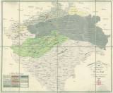
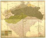
 Geonostische Charte von Böhmen Geonostische Charte von Böhmen(Geological map of Bohemia ) Author: Riepl, Franz Author's comment: Drawn and engraved by Albert Richard, printed by von Phillisdorf Country: Czech Republic; Czech Crownlands Document language: German Publisher: publisher not specified, first edition Black and white print with demarkation of lithological formations, colored by hand and supplied with two additional handwritten symbols in the legend Year: 1819 Scale: 1 : 576 000 Theme of the map: petrographical map Type: Map Color: Coloured Form: Loose map Kind: Printed Original source for this digital copy : Czech Geological Survey, Prague , Map collection of Charles University, Prague Original dimensions: 516 x 610 mm (height x width) |


