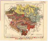
 Geologická mapa okresu chrudimského a nasavrckého Geologická mapa okresu chrudimského a nasavrckéhoPříloha k dílu"Chrudimsko a Nasavrcko" (Geological map of the Chrudim and Nasavrky districts ) (Supplement to the publication "Chrudimsko a Nasavrcko" (The Chrudim and Nasavrky regions)) Author: Kudrna, Karel Author's comment: Drawn by J. Homolka. Typography by "Unie", Prague Country: Czech Republic; Czech Crownlands Document language: Czech Publisher: Výbor ku popisu okresu chrudimského a nasavrckého, b.m. Published as a supplement to the monograph: "Chrudimsko a Nasavrcko" (The Chrudim and Nasavrky regions) Vol.1 – The nature, to a paper by K.Kudrna: Geologie (Geology). Chrudim 1906. The map has also been published separately Year: 1906? Scale: 1 : 100 000 Theme of the map: geological map with Quaternary deposits Type: Map Color: Coloured Form: Loose map Kind: Printed Original source for this digital copy : Czech Geological Survey, Prague Original dimensions: 287 x 339 mm (height x width) |


