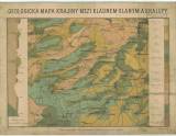
 Geologická mapa krajiny mezi Kladnem, Slaným a Kralupy Geologická mapa krajiny mezi Kladnem, Slaným a Kralupy(Geological map of the area between Kladno, Slaný and Kralupy) Author's comment: Drawn by V. Spousta. Typography by Farský, Prague Country: Czech Republic; Czech Crownlands Document language: Czech Publisher: b.v., b.m. Taken from geol.maps by Professor J.Krejčí, R.Helmhacker and senior mining counsellor M.Lipold Year: Scale: 1 : 43 200 Theme of the map: geological map with Quaternary deposits Type: Map Color: Coloured Form: Loose map Kind: Printed Original source for this digital copy : Czech Geological Survey, Prague Original dimensions: 380 x 420 mm (height x width) |


