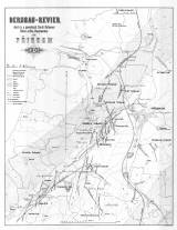
 Bergbau-revier des k.k. & gewerksch. Caroli Boromaei Silber-& Blei-Hauptwerkes zu Příbram 1875 Bergbau-revier des k.k. & gewerksch. Caroli Boromaei Silber-& Blei-Hauptwerkes zu Příbram 1875(Mining district and the main operation of silver and lead extraction in state ownership and mine ownership by Karel Boromejský in Příbram 1875) Author's comment: Print K.k. Markscheiderei zu Přibram. Drawn by A. Plamínek (?). Typography by von Waldheim, Wien Country: Czech Republic; Czech Crownlands Document language: German Publisher: K.k. Berg-Direction zu Příbram, Wien, first edition Supplement to the publication: Der Silber- und Blei-Bergbau zu Příbram (Böhmen). Zur Feier der im Adalbert-Schacht erreichten Saigerteufe von 1000 Meter. Wien 1875 Year: 1875 Scale: 1 : 14 400 Theme of the map: map of mineral deposits Type: Map supplement Color: Black and white Form: Bound appendix Kind: Printed Original source for this digital copy : Czech Geological Survey, Prague Original dimensions: 548 x 423 mm (height x width) |


