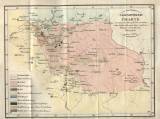
 Geognostische Charte des rothen Sandsteingebildes zwischen dem linken Iser- und dem rechten Elbeufer Geognostische Charte des rothen Sandsteingebildes zwischen dem linken Iser- und dem rechten Elbeuferentworfen von Moteglek im Jahre 1829 (Geological map of red sandstone formation between the left bank of the River Jizera and right bank of the River Labe) (Compiled by Motejlek in 1829) Author: Moteglek (Motejlek), Joseph Author's comment: Lithography by M.J. Štiasny. Typography by J.F. Zwettler Country: Czech Republic; Czech Crownlands Document language: German Publisher: b.v., Prague, first edition Supplement to the book by J. Motejlek (Moteglek): Das rothe Sandsteingebilde zwischen dem linken Iser- und rechten Elbeufer am südlichen Fusse des Iser- und Riesengebirges geognostisch geschildert von...". Praha 1829 Year: 1829? Scale: 1 : 125 000 Theme of the map: petrographical map Type: Map supplement Color: Coloured Form: Bound appendix Kind: Printed Original source for this digital copy : Czech Geological Survey, Prague Original dimensions: 282 x 373 mm (height x width) |


