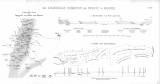
 Die Steinkohlen-Formation bei Rossitz in Maehren. Geognostische Karte der Umgegend von Rossitz und Oslawan Die Steinkohlen-Formation bei Rossitz in Maehren. Geognostische Karte der Umgegend von Rossitz und Oslawan(Hard-coal unit near Rosice in Moravia. Geological map of the environs of Rosice and Oslavany) Country: Czech Republic; Czech Crownlands Document language: German Publisher: R. Oldenbourg, München, first edition Published (Figure 24)in map collection by H.B.Geinitz: Atlas zur Geologie der Steinkohlen Deutschland's und anderer Länder Europa's;, together with geological map acompanied by an E-W geological cross-section Year: 1865 Scale: 1 : 144 000 Theme of the map: map of mineral deposits, geological map with Quaternary deposits Type: Map supplement Color: Black and white Form: Bound appendix Kind: Printed Original source for this digital copy : Library of the Faculty of Science, Charles University, Prague Original dimensions: 204 x 202 mm (height x width) |


