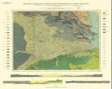
 Geologische Übersichtskarte des Oberschlesischen Steinkohlenreviers und seiner Nachbargebiete Geologische Übersichtskarte des Oberschlesischen Steinkohlenreviers und seiner Nachbargebiete(General geological map of the Upper Silesian hard-coal district and adjacent areas) Author: Michael, Richard Author's comment: Drawn by J. Nowak 1911. Lithography and typography by L. Kraatz, Berlin Country: Czech Republic; Poland; Czech Crownlands; Prussian Silesia Document language: German Publisher: Königliche Preussische Geologische Landesanstalt, Berlin, first edition Supplement (Appendix 5) to a paper by G. Berga:Der geologische Bau des niederschlesisch-böhmischen Beckens und seiner Umgebung,published in "Festschrift zum XII. Allgemeinen Deutschen Bergmannstage in Breslau 1913. Der Bergbau im Osten des Köhigsreichs Preussen Year: 1913 Scale: 1 : 100 000 Theme of the map: geological map with Quaternary deposits, map of mineral deposits Type: Map supplement Color: Coloured Form: Folded map Kind: Printed Original source for this digital copy : Library of the Faculty of Science, Charles University, Prague Original dimensions: 496 x 718 mm (height x width) |


