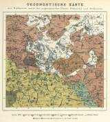
 Geognostische Karte der Südlausitz sowie der angrenzenden Theile Böhmens und Schlesiens Geognostische Karte der Südlausitz sowie der angrenzenden Theile Böhmens und Schlesiens(Geological map of southern Lusatia and border areas of Bohemia and Silesia) Author: Friedrich, Oskar Oswald Author's comment: Lithography by L. Michel. Typ. Th. Busch, Zittau Country: Czech Republic; Czech Crownlands Document language: German Publisher: Johanneum, Zittau, first edition Supplement to a paper by O.O. Friedrich: Kurze geognostische Beschreibung der Südlausitz und der angrenzenden Theile Böhmens und Schlesiens, mit einer geognostischen Karte dieser Gegenden. Zittau 1871 Year: 1871 Scale: 1 : 157 000 Theme of the map: geological map with Quaternary deposits, map of mineral deposits Type: Map supplement Color: Coloured Form: Bound appendix Kind: Printed Original source for this digital copy : Library of the Faculty of Science, Charles University, Prague Original dimensions: 300 x 316 mm (height x width) |


