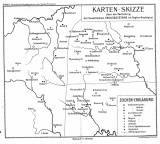
 Karten-Skizze über die Verteilung der basaltischen Ergussgesteine im Tepler Hochland Karten-Skizze über die Verteilung der basaltischen Ergussgesteine im Tepler Hochland(Sketch map of distribution of basalt volcanic rocks in the Tepelská vysočina Highland) Author: Pohl, Oskar Author's comment: Lithography by A. Haase, Prague Country: Czech Republic; Czech Crownlands Document language: Czech Publisher: Fr. Řivnáč (commission publisher), Prague, first edition Supplement to a paper by O. Pohl: Basaltische Ergussgesteine von Tepler Hochland (Basalt volcanics of the Tepelská vysočina Highland)", published simultaneously in Czech and German version in edition "Archiv pro přírodovědecký výzkum Čech (Archiv der naturwissenschaftlichen Landesdurchforschung von Böhmen)", vol. XIII/3 Year: 1905 Scale: 1 : 200 000 Theme of the map: petrographical map Type: Map supplement Color: Black and white Form: Bound appendix Kind: Printed Original source for this digital copy : Czech Geological Survey, Prague Original dimensions: 260 x 298 mm (height x width) |


