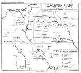
 Náčrtek mapy o rozšíření čedičových vyvřelých hornin v Tepelské vysočině Náčrtek mapy o rozšíření čedičových vyvřelých hornin v Tepelské vysočině(Sketch map of distribution of basalt volcanic rocks in the Tepelská vysočina Highland) Author: Pohl, Oskar Author's comment: Lithography by A. Haase, Prague Country: Czech Republic; Czech Crownlands Document language: Czech Publisher: Fr. Řivnáč (commission publisher), Prague, first edition Supplement to a paper by O.Pohl: „Basalt volcanics of the Tepelská vysočina Highland“, published simultaneously in Czech and German version in edition "Archiv pro přírodovědecký výzkum Čech (Archiv der naturwissenschaftlichen Landesdurchforschung von Böhmen)", vol. XIII/3 Year: 1908 Scale: 1 : 200 000 Theme of the map: petrographical map Type: Map supplement Color: Black and white Form: Bound appendix Kind: Printed Original source for this digital copy : Czech Geological Survey, Prague Original dimensions: 260 x 298 mm (height x width) |


