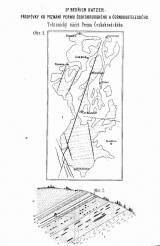
 Tektonický náčrt Permu Českobrodského Tektonický náčrt Permu Českobrodského(Tectonic sketch of the Český Brod Permian) Author: Katzer, Bedřich (Friedrich) Country: Czech Republic; Czech Crownlands Document language: Czech Publisher: Čes. akad. cís. Františka Josefa pro vědy, slovesnost a umění, Prague, first edition Supplement to a paper by B.Katzer: Contribution to the knowledge of the Permian in the area of Český Brod and Kostelec nad Černými Lesy, published in "Rozpravy České akademie císaře Františka Josefa pro vědy, slovesnost a umění, Třída II, vol.IV, No.23. Praha 1895 Year: 1895 Scale: 1 : 200 000 Theme of the map: tectonic map Type: Map supplement Color: Black and white Form: Bound appendix Kind: Printed Original source for this digital copy : Czech Geological Survey, Prague Original dimensions: 137 x 70 mm (height x width) |


