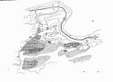
 [Geologie území mezi Litní-Zad. Třebání-Poučníkem] [Geologie území mezi Litní-Zad. Třebání-Poučníkem](Geology of the area between Liteň-Zad.Třebáň-Poučník) Author: Woldřich, Josef Country: Czech Republic; Czech Crownlands Document language: Czech Publisher: Česká společnost zeměvědná, Prague, first edition Supplement (surprint to Table 1) to a paper by J.Woldřich: : On tectonic, Tertiary and glacial epoch of the area between the river Berounka near Budňany, Zadní Třebáň and Liteň, published in "Sborník České společnosti zeměvědné", vol. 20. Praha 1914 Year: 1914 Scale: 1 : 25 000 Theme of the map: geological map with Quaternary deposits Type: Map surprint Color: Black and white Form: Bound supplement Kind: Tracing paper Original source for this digital copy : Czech Geological Survey, Prague |


