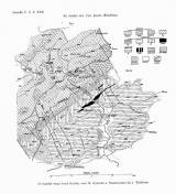
 Geologická mapa úvodí Kačáku mezi M. Kyšicemi a Nenačovicemi Geologická mapa úvodí Kačáku mezi M. Kyšicemi a Nenačovicemidle J. Woldřicha (Geological map of the Kačák catchment between M.Kyšice and Nenačovice) (after J.Woldřich ) Author: Woldřich, Josef Country: Czech Republic; Czech Crownlands Document language: Czech Publisher: Česká společnost zeměvědná, Prague, first edition Supplement to a paper by J.Woldřich: Morphological-tectonic study of the Kačák catchment south of Unhošť, published in "Sborník České společnosti zeměvědné", vol.22. Praha 1916 Year: 1916 Scale: 1 : 40 000 Theme of the map: geological map with Quaternary deposits Type: Map supplement Color: Black and white Form: Bound appendix Kind: Printed Original source for this digital copy : Czech Geological Survey, Prague Original dimensions: 180 x 185 mm (height x width) |


