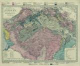
 [Geologická mapa Království českého a přilehlých oblastí] [Geologická mapa Království českého a přilehlých oblastí](Geological map of the Kingdom of Bohemia and adjacent areas) Author: Preininger, Andreas Country: Austria; Czech Republic; Czech Crownlands; Germany Document language: German Publisher: publisher not specified Colored map with geological features drawn into printed topographic map marked as "Königreich Böhmen nach den neuesten Beobachtungen verfast. Wien, by Florian Mollo".Holograph map, published at reduced scale in Věstník ČGÚ, vol.68,No.1 Year: 1837 Scale: 1 : 1 100 000 Theme of the map: geological map with Quaternary deposits Type: Map Color: Coloured Form: Loose map Kind: manuscript Original source for this digital copy : Czech Geological Survey, Prague Original dimensions: 316 x 424 mm (height x width) |


