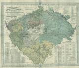
 Geognostisch-montanistische, Geschäfts- und Comunicationenkarte des Königreiches Böhmen Geognostisch-montanistische, Geschäfts- und Comunicationenkarte des Königreiches Böhmen(Geognostic-mining, commercial and transport map of the Bohemian Kingdom) Author: Schmidt von Bergenhold, Johann Ferdinand Author's comment: Lithographer Mittag und Wildner, Praha Country: Czech Republic; Czech Crownlands Document language: German Publisher: Rziwnač, Prague Year: 1873 Scale: 1 : 400 000 Theme of the map: geological map with Quaternary deposits, map of mineral deposits Type: Map Color: Coloured Form: Folded map Kind: Printed Original source for this digital copy : Czech Geological Survey, Prague Original dimensions: 735 x 909 mm (height x width) |


