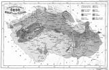
 Zeměznalecký přehled Čech, Moravy a části Slezska Zeměznalecký přehled Čech, Moravy a části Slezska(Earth scientific/geographic outline of Bohemia, Moravia and part of Silesia ) Author: Kodym, Filip Stanislav Author's comment: Lithography M.A. Vítek, Prague Country: Czech Republic; Czech Crownlands Document language: Czech Publisher: B. Rohlíček, Prague, first edition Supplement to the book by F.S. Kodyma: Úvod do zemězpytu, čili prostonárodní výklad všelikých proměn a podvratů, s nimiž země naše se potkala, prvé než nynější své tvářnosti dosáhla (Introduction to earth sciences or simpliest exposition of various changes and faults which our country suffered from before it reached its present shape). Praha 1855 Year: 1855 Scale: 1 : 1 940 000 Theme of the map: geological map without Quaternary deposits Type: Map supplement Color: Shades of gray Form: Bound appendix Kind: Printed Original source for this digital copy : Czech Geological Survey, Prague , Czech Geological Survey, Prague Original dimensions: 168 x 268 mm (height x width) |


