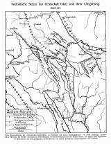
 Tektonische Skizze der Grafschaft Glatz und ihrer Umgebung Tektonische Skizze der Grafschaft Glatz und ihrer Umgebung(Tectonic sketch of the Kladsko county and its neighborhood ) Author: Flegel, Kurt Author's comment: based on data provided by Frech, Leppl and own Country: Czech Republic; Czech Crownlands Document language: German Publisher: publisher not specified, first edition Supplement (Table 3) to a paper by K. Flegel: Heuscheuer und Adersbach-Weckelsdorf. Eine Studie über die obere Kreide im böhmisch-schlesischen Gebirge, presumably published in "Zetschrift der Deutschen geologischen Gesellschaft". Breslau 1904. 3rd part Year: 1904? Scale: 1 : 400 000 Theme of the map: tectonic map Type: Map supplement Color: Black and white Form: Folded map Kind: Printed Original source for this digital copy : Czech Geological Survey, Prague Original dimensions: 280 x 232 mm (height x width) |


