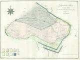
 Geognostische Skizze von einem Theile des schlesischen, b÷hmischen, und lausitzer Gebirges Geognostische Skizze von einem Theile des schlesischen, b÷hmischen, und lausitzer Gebirgesentworfen von Carl von Raumer (Geognostic sketch map of a part the Silesian, Bohemian and Lusatian mountain area) (Compiled by K.von Raumer) Author: Raumer, Karl von Country: Czech Republic; Czech Crownlands Document language: German Publisher: Realschul-Buchhandlung, Berlin, first edition Supplement to the book by K. von Raumer: Der Granit des Riesengebirges und die ihn umgebenden Gebirgs-Familien. Berlin 1813 Year: 1813 Scale: 1 : 155 200 Theme of the map: geological map with Quaternary deposits Type: Map Color: Coloured Form: Bound appendix Kind: Printed Original source for this digital copy : National Museum, Prague Original dimensions: 384 x 524 mm (height x width) |