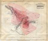
 Charte der Verbreitung und Intensität des Erdbebens am 15. Jänner 1858 Charte der Verbreitung und Intensität des Erdbebens am 15. Jänner 1858(Map of distribution and strenght of the earthquake of January 15, 1858 ) Author: Schmidt, Julius J.F. Author's comment: Printed by "Litogr.lit.art. Anstalt in Wien" Country: Austria; Czech Republic; Slovakia; Czech Crownlands Document language: German Publisher: b.v., Wien, first edition Supplement (Table 2) to a paper by by J.F.J.Schmidt: Untersuchungen über das Erdbeben am 15. Jänner 1858, published in Mittheilungen der k.k. geographischen Gesellschaft, II. Jahrg., 2 Heft Year: 1858? Scale: 1 : 2 000 000 Theme of the map: earthquake map Type: Map supplement Color: Coloured Form: Bound appendix Kind: Printed Original source for this digital copy : private collection of Dr.J.Kozák Original dimensions: 245 x 285 mm (height x width) |


