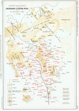
 Verbreitungsgebiet des Erdbebens am Böhm. Phahl vom 26. November 1902 Verbreitungsgebiet des Erdbebens am Böhm. Phahl vom 26. November 1902(The area of earthquake of November 26, 1902, in the Czech border area) Author: Knett, J. Author's comment: Print Th.Bannwarth, Wien Country: Czech Republic; Czech Crownlands Document language: German Publisher: publisher not specified, first edition Supplement (Table 1) to "Mitteilungen d. Erdbeben-Kommission d. Kais. Akad. D. Wiss.", No. XVIII, 1903 Year: 1903 Scale: 1 : 576 000 Theme of the map: petrographical map, earthquake map Type: Map Color: Coloured Form: Loose map Kind: Photo copy Original source for this digital copy : private collection of Dr.J.Kozák Original dimensions: 275 x 185 mm (height x width) |


