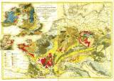
 Geognostische Karte von Central- und West-Europa einschlieslich der Britischen Inseln, Frankreich, Deutschland und der Nachbarländer Geognostische Karte von Central- und West-Europa einschlieslich der Britischen Inseln, Frankreich, Deutschland und der Nachbarländer(Geognostic map of central and western Europe incuding British Islands, France, Germany and neighbour countries) Country: Czech Republic; Great Britain; Czech Crownlands; Europe Document language: German Publisher: Verlag des Bibliographischen Instituts, Hildburghausen, first edition Color photo copy of initially two sheets glued together (I.Westl.Haelfte, II. Oest.Haelfte) Meyer's-Handatlas, No.29, No.30 Year: 1844? Scale: 1 : 4 400 000 Theme of the map: geological map with Quaternary deposits Type: Map Color: Coloured Form: Loose sheet Kind: Photo copy Original source for this digital copy : private collection of Dr.J.Kozák Original dimensions: 385 x 557 mm (height x width) |


