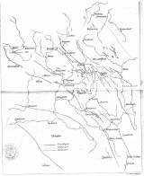
 [Tektonická skica české části středních Sudet] [Tektonická skica české části středních Sudet](Tectonic sketch of Czech part of central Sudeten) Author: Petrascheck, W.J. Author's comment: Printer J.F.Starcke, Berlin Country: Czech Republic; Czech Crownlands Document language: German Publisher: publisher not specified, first edition Supplement – transparent (Table 35) to a paper by W. Petraschek: Das Bruchgebiet des böhmischen Anteils der Mittelsudeten westlich des Neissegrabens, published in "Zeitschrift der Deutschen geologischen Gesellschaft", vol. 56. Berlin 1904 Year: 1904 Scale: 1 : 200 000 Theme of the map: tectonic map Type: Map supplement Color: In one colour Form: Bound appendix Kind: Printed Original source for this digital copy : Czech Geological Survey, Prague Original dimensions: 263 x 205 mm (height x width) |


