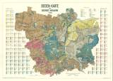
 Boden - Karte des Bezirkes Welwarn 1:25 000 Boden - Karte des Bezirkes Welwarn 1:25 000(Map of soil conditions of the Velvary district 1:25 000) Authors: Kopecký, Josef; Janota, Rudolf Country: Czech Republic; Czech Crownlands Document language: German Publisher: Fr. Řivnáč (commission publisher), Prague, first edition Published concurrently in Czech and German version in edition " Archiv pro přírodovědecký výzkum Čech /Archiv für die naturwissenschaftliche Landesdurchforschung von Böhmen", vol. XVI/1 Year: 1915 Scale: 1 : 25 000 Theme of the map: soil map Type: Map Color: Coloured Form: Folded map Kind: Printed Original source for this digital copy : Czech Geological Survey, Prague Original dimensions: 692 x 987 mm (height x width) |
| Other variety of this document |


