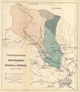
 Übersichts-Karte der Niederschlagsgebiete des Flössbaches und Malstbaches Übersichts-Karte der Niederschlagsgebiete des Flössbaches und Malstbaches(Synoptic map of infiltration areas of the river Bystřice and the Modlany creek) Author: Poech, Wenzel Author's comment: Lithography and printing by E.Rennert, Ústí nad Labem Country: Czech Republic; Czech Crownlands Document language: German Publisher: Communal-Obergymnasium, Aussig, first edition Supplement to a paper by Georg Bruder: Beitäge zur Kenntnis der Grundwasser-Verhältnisse der Niederschlagsgebiete des Flössbaches und Malstbaches Year: 1898 Scale: 1 : 25 000 Theme of the map: hydrogeological map Type: Map supplement Color: Coloured Form: Bound appendix Kind: Printed Original source for this digital copy : Czech Geological Survey, Prague Original dimensions: 420 x 362 mm (height x width) |


