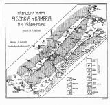
 Přehledná mapa algonkia a kambria na Příbramsku Přehledná mapa algonkia a kambria na Příbramsku(Synoptic map of the Algonkian and Cambrian in the Příbram region) Author: Kettner, Radim Author's comment: Typographic Union, Praha Country: Czech Republic; Czech Crownlands Document language: Czech Publisher: Čes. akad. cís. Františka Josefa pro vědy, slovesnost a umění, Prague, first edition Supplement to a paper by R.Kettner: On Žitec conglomerates – the lowermost horizon of the Bohemian Cambrian published in "Rozpravy České akademie císaře Františka Josefa pro vědy, slovesnost a umění, Třída II", vol. XXIV, No. 34. Praha 1915 Year: 1915 Scale: 1 : 140 000 Theme of the map: geological map without Quaternary deposits Type: Map supplement Color: Black and white Form: Bound appendix Kind: Printed Original source for this digital copy : Czech Geological Survey, Prague Original dimensions: 197 x 212 mm (height x width) |


