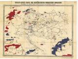
 Kohlen-Revier-Karte der Österreichisch-Ungarischen Monarchie Kohlen-Revier-Karte der Österreichisch-Ungarischen Monarchie(Map of coal districts of the Austro-Hungarian monarchy ) Author: Pechar, Johann Author's comment: Lithography by "Bohemia", Prague Country: Czech Republic; Czech Crownlands; Austria-Hungary Document language: German Publisher: C.H. Hunger's Nachfolger, Prague, second edition Year: 1873 Scale: 1 : 2 200 000 Theme of the map: map of mineral deposits Type: Map Color: Coloured Form: Loose map Kind: Printed Original source for this digital copy : Czech Geological Survey, Prague Original dimensions: 534 x 713 mm (height x width) |


