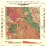
 Geologische Specialkarte des Königreichs Sachsen Geologische Specialkarte des Königreichs SachsenSection Altenberg-Zinnwald No. 119 (Geological special map of the Kingdom of Saxony) (Section Altenberg-Cínovec No.119) Authors: Gäbert, Carl; Dalmer, Karl Author's comment: 1st edition (1888) by K.Dalmer, published in 1890, revised by C. Gäbert in 1906 Country: Czech Republic; Czech Crownlands; Saxony; Austria-Hungary; Germany Document language: German Publisher: Königliche Finanz-Ministerium, Leipzig, second edition reprint – added new numerical index 5248 Year: 1908 Scale: 1 : 25 000 Theme of the map: geological map with Quaternary deposits Type: Map Color: Coloured Form: Loose map Kind: Printed Original source for this digital copy : Czech Geological Survey, Prague Original dimensions: 475 x 500 mm (height x width) |


