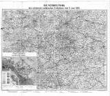
 Die Verbreitung des schlesisch-sedetischen Erdbebens vom 11. Juni 1895 Die Verbreitung des schlesisch-sedetischen Erdbebens vom 11. Juni 1895Geologische Übersichtskarte der Erschütterungs-gebiete (Distribution of Silesian-Sudeten earthquake swarm of July 11, 1895) (Synoptic geological sketch map of tremor areas) Author: Dathe, Ernst Author's comment: Lithography by L. Kraatz, Berlin Country: Czech Republic; Czech Crownlands; Prussia Document language: German Publisher: Königliche Preussische Geologische Landesanstalt, Berlin, first edition Attached to a paper by E. Dathe: Das schlesisch-sudetische Erdbeben vom 11. Juni 1895, published as 22th volume of "Abhandlungen der Königlich Preussischen geologischen Landesanstalt. Neu Folge". Berlin 1897. Ed. Simon Schropp Year: 1897 Scale: 1 : 300 000 Theme of the map: earthquake map, topographical map Type: Map supplement Color: Coloured Form: Bound appendix Kind: Printed Original source for this digital copy : Czech Geological Survey, Prague Original dimensions: 179 x 212 mm (height x width) |


