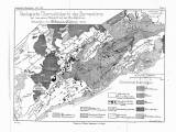
 Geologische Übersichskarte des Barrandiens mit besonderer Rücksicht auf das böhmische Algonkium Geologische Übersichskarte des Barrandiens mit besonderer Rücksicht auf das böhmische Algonkium(Synoptic geological map of the Barrandian with a special emphasis on the Bohemian Algonkian) Author: Kettner, Radim Country: Czech Republic; Czech Crownlands Document language: German Publisher: Verlag Wilhelm Engelmann, Leipzig, first edition Supplement (Table 1) to a paper by R. Kettner: Versuch einer stratigraphischen Einteilung des böhmischen Algonkiums, published in "Geologische Rundschau", vol.8 Leipzig 1917. Ed. W. Engelmann-Verlag Year: 1917 Scale: 1 : 500 000 Theme of the map: geological map with Quaternary deposits Type: Map supplement Color: Black and white Form: Bound appendix Kind: Printed Original source for this digital copy : Czech Geological Survey, Prague Original dimensions: 213 x 281 mm (height x width) |


