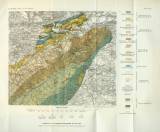
 Silur an der Beraun Silur an der Beraun[Geologická mapa oblasti Hřebenů mezi Všeradicemi, Budňany, Dobřichovicemi, Mníškem a Voznicí] (Silurian in the area of the Berounka River) Author: Nowak, Ernst Author's comment: Lithography and typography by Militärgeographisches Institut, Wien Country: Czech Republic; Czech Crownlands Document language: German Publisher: Kaiserlich-königliche Geologische Reichsanstalt, Wien, first edition Supplement (Table 8) to a paper by E. Nowak: Geologische Untersuchungen im Südflügel des mittelböhmischen Silur, published in "Jahrbuch der k.k. geologischen Reichsanstalt", vol.64. Wien 1914 Year: 1914 Scale: 1 : 75 000 Theme of the map: geological map with Quaternary deposits Type: Map supplement Color: Coloured Form: Bound appendix Kind: Printed Original source for this digital copy : Czech Geological Survey, Prague Original dimensions: 204 x 232 mm (height x width) |


