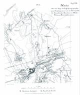
 Karte über die Lage der Auffahrungspunkte eines Eruptivgesteins und der Fundpunkte der Basaltischen Bomben im Mährisch-Ostrauer Steinkohlenrevier Karte über die Lage der Auffahrungspunkte eines Eruptivgesteins und der Fundpunkte der Basaltischen Bomben im Mährisch-Ostrauer Steinkohlenrevier(Map showing location of outcrops of igneous rocks and occurrences of basalt bombs in Moravia-Ostrava black coal district) Author's comment: Lithography by F. Köke, Wien Country: Czech Republic; Czech Crownlands Document language: German Publisher: Kaiserlich-königliche Geologische Reichsanstalt, Wien, first edition Supplement (Table 8) to a paper by J. Niedzwiedzki: Bazalt-Vorkommnisse im Mährisch-Ostrauer Steinkohlenbecken, published in "Jahrbuch der k.k. geologischen Reichsanstalt", vol.23. Wien 1873 Year: 1873 Scale: 1 : 14 400 Theme of the map: petrographical map Type: Map supplement Color: Black and white Form: Bound appendix Kind: Printed Original source for this digital copy : Czech Geological Survey, Prague Original dimensions: 320 x 275 mm (height x width) |


