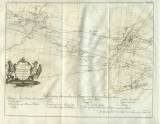
 Grund Riss über die Bergwerksgegend Zwischen Deutschbrod in Böhmen, und Iglau in Mährn Grund Riss über die Bergwerksgegend Zwischen Deutschbrod in Böhmen, und Iglau in Mährn(Profile of the mining area between Německý [Havlíčkův Brod]in Bohemia and Jihlava in Moravia) Author: Peithner von Lichtenfels, Johann Thaddäus Anton Author's comment: Engraver Jakob Adam, Wien 1780 Country: Czech Republic; Czech Crownlands Document language: German Publisher: publisher not specified, first edition Supplement to the book: Johann Thaddäus Anton Peithners Versuch über die natürliche und politische Geschichte der böhmischen und mährischen Bergwerke. Wien 1780 Year: 1780 Scale: 1 : 75 000 Theme of the map: map of mineral deposits Type: Map supplement Color: Black and white Form: Bound appendix Kind: Printed Original source for this digital copy : Czech Geological Survey, Prague Original dimensions: 276 x 355 mm (height x width) |


