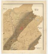
 Montan Geologische Karte des Bergbau-Terrains Příbram-Birkenberg Montan Geologische Karte des Bergbau-Terrains Příbram-Birkenberg(Mining and geological map of the mining district of Příbram-Březové Hory) Author: Schmid, Josef Author's comment: Mapping 1886 - 1890 Country: Czech Republic; Czech Crownlands Document language: German Publisher: publisher not specified, first edition Supplement to a paper by W. Göbl: Montan-geologische Beschreibung des Příbramer Bergbau-Terrains und der Verhältnisse in der Grube nach dem gegenwärtigen Stande des Aufschlusses in diesem Terrain. Wien 1892. Ed. k.k. Bergdirection in Pribram Year: 1892? Scale: 1 : 14 400 Theme of the map: geological map with Quaternary deposits, map of mineral deposits Type: Map Color: Coloured Form: Set of sequential loose sheets Kind: Printed Original source for this digital copy : Czech Geological Survey, Prague Original dimensions: 621 x 527 mm (height x width) |


