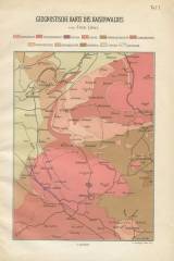
 Geognostische Karte des Kaiserwaldes Geognostische Karte des Kaiserwaldes(Geognostic map of the Císařský [Slavkovský]les) Author: Löwl, Ferdinand Author's comment: Editor H.Dominicus, printing k.k.Hoftihogr.v.A.Haase in Prague Country: Czech Republic Document language: German Publisher: H. Dominicus, Prague, first edition Supplement to a paper by F. Löwl: Die Granit-Kerne des Kaiserwaldes bei Marienbad. Ein Problem der Gebirgskunde. Praha 1885 (Taf. I) Year: 1885 Scale: 1 : 125 000 Theme of the map: petrographical map Type: Map supplement Color: Coloured Form: Bound supplement Kind: Printed Original source for this digital copy : Czech Geological Survey, Prague Original dimensions: 187 x 139 mm (height x width) |


