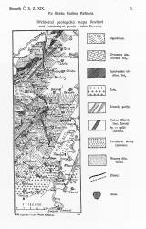
 Přehledná geologická mapa Povltaví mezi Svatojanskými proudy a ústím Berounky Přehledná geologická mapa Povltaví mezi Svatojanskými proudy a ústím Berounky(Synoptic map of the river Vltava region between Svatojánské rapids and mouth of the river Sázava) Author: Kettner, Radim Country: Czech Republic; Czech Crownlands Document language: Czech Publisher: Česká společnost zeměvědná, Prague, first edition Supplement to a paper by R.Kettner: On the Vltava River terraces between the Svatojánské rapids and Zbraslav, published in „Sborník České společnosti zeměvědné“, vol.19. Praha 1913 Year: 1912 Scale: 1 : 150 000 Theme of the map: geological map with Quaternary deposits Type: Map supplement Color: Black and white Form: Bound supplement Kind: Printed Original source for this digital copy : Czech Geological Survey, Prague Original dimensions: 182 x 66 mm (height x width) |


