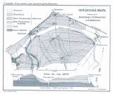
 Geologická mapa krajiny mezi Lovosicemi, Čížkovicemi a Lukavcem Geologická mapa krajiny mezi Lovosicemi, Čížkovicemi a Lukavcem(Geological map of the area between Lovosice, Číškovice and Lukavec) Author: Zahálka, Čeněk Country: Czech Republic; Czech Crownlands Document language: Czech Publisher: Královská Česká společnost nauk, Prague, first edition Supplement to a paper by Č.Zahálka: The first report on geology of the Brozany hill. Area between Lovosice, Čížkovice and Lukavec, published in „Zprávy o zasedání Královské České společnosti nauk v Praze“, vol.1884. Praha 1884 (chapter 36, pp.290-316) Year: 1884 Scale: 1 : 25 000 Theme of the map: geological map with Quaternary deposits Type: Map supplement Color: Black and white Form: Bound appendix Kind: Printed Original source for this digital copy : Czech Geological Survey, Prague Original dimensions: 182 x 222 mm (height x width) |


