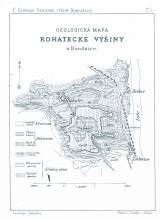
 Geologická mapa Rohatecké výšiny u Roudnice Geologická mapa Rohatecké výšiny u Roudnice(Geological map of the Rohatec hill near Roudnice) Author: Zahálka, Čeněk Author's comment: Lithography by Farský. Praha Country: Czech Republic; Czech Crownlands Document language: Czech Publisher: Královská Česká společnost nauk, Prague, first edition Supplement to a paper by Č.Zahálka: Geology of the Rohatec hill near Roudnice nad Labem, published in Zprávy o zasedání Královské České společnosti, Třída mathematicko-přirodovědecká, vol.1885. Praha 1886 (pp.353-386) Year: 1886 Scale: 1 : 40 000 Theme of the map: geological map with Quaternary deposits Type: Map supplement Color: Black and white Form: Bound supplement Kind: Printed Original source for this digital copy : Czech Geological Survey, Prague Original dimensions: 182 x 119 mm (height x width) |


