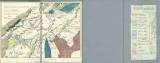
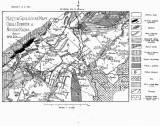
 Nástin geologické mapy okolí Dobříše a Nového Knína Nástin geologické mapy okolí Dobříše a Nového Knína(Geological sketch map of the environs of Dobříš and Nový Knín ) Author: Kettner, Radim Country: Czech Republic; Czech Crownlands Document language: Czech Publisher: Česká společnost zeměvědná, Prague, first edition Supplement to a paper by R.Kettner: Report on geological studies in the environs of Dobříš and Nový Knín, published in „Sborník České společnosti zeměvědné“, vol.21, Praha 1915 Year: 1915 Scale: 1 : 75 000 Theme of the map: geological map with Quaternary deposits Type: Map supplement Color: Black and white Form: Bound supplement Kind: Printed Original source for this digital copy : Czech Geological Survey, Prague , collection of Professor Kettner Original dimensions: 168 x 236 mm (height x width) |


