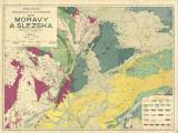
 Přehledná geologická a tektonická mapa Moravy a Slezska Přehledná geologická a tektonická mapa Moravy a Slezska(General geological and tectonic map of Moravia and Silesia ) Authors: Jahn, Jaroslav Jiljí; Beck, Henrich Author's comment: Hungarian part compiled by Dr. H. Beck. Lithography and printing by Th. Bannwarth, Vienna Country: Czech Republic; Poland; Slovakia; Czech Crownlands; Austria-Hungary Document language: Czech Publisher: Komise pro přírodovědovědecké prozkoumání Moravy, Brno, first edition Year: 1911 Scale: 1 : 300 000 Theme of the map: geological map with Quaternary deposits, tectonic map Type: Map Color: Coloured Form: Loose map Kind: Printed Original source for this digital copy : Czech Geological Survey, Prague Original dimensions: 700 x 954 mm (height x width) |


