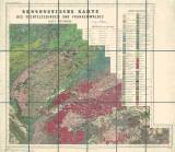
 [Geognostische Karte des Koenigreichs Bayern, Dritte Abtheilung] [Geognostische Karte des Koenigreichs Bayern, Dritte Abtheilung]Geognostische Karte des Fichtelgebirges und Frankenwaldes - Blatt Münchberg (No XI) (Geological map of the Kingdom of Bavaria, Third part ) (Geological map of Smrčiny (Fichtelgebirge) and Francký les (Frankenwald) – map sheet Münchberg (No.XI)) Author: Gümbel, Carl Wilhelm Author's comment: Drawn by Ed.Gronen, Lithography by V.Geyer, printed by C.Hellfarth Country: Czech Republic; Czech Crownlands; Bavaria; Germany Document language: German Publisher: Justus Perthes, Gotha, first edition The map sheet also includes the border areas of the Aš and Cheb regions Year: 1877 Scale: 1 : 100 000 Theme of the map: geological map with Quaternary deposits Type: Map Color: Coloured Form: Folded map Kind: Printed Original source for this digital copy : Map collection of the estate of Professor Kettner, Charles University, Prague Original dimensions: 610 x 612 mm (height x width) |


