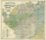
 Geognostische Karte der Umgebungen von Carlsbad, Franzensbad und Marienbad Geognostische Karte der Umgebungen von Carlsbad, Franzensbad und Marienbadentworfen nach den Aufnahmen der k.k. geologischen Reichsanstalt (Geognostic map of the environs of Karlovy Vary, Františkovy Lázně and Mariánské Lázně) (Compiled and based on studies of c.k. Imperial Geological Survey ) Author: Reuss, August Emanuel Author's comment: Lithography by J. Sandtner. Typography by F.E. Sandtner, Prague Country: Czech Republic; Czech Crownlands Document language: German Publisher: Adolf Becker, Teplice, first edition Supplement to the book by A. E. Reuss: Geognostische Skizze der Umgebung von Carlsbad, Marienbad und Franzensbad. Teplice-Šanov, without notation of date of issue (after Kettner and Laube in 1863); different colored version published as separate print (?) Year: 1863? Scale: 1 : 144 000 Theme of the map: petrographical map Type: Map supplement Color: Coloured Form: Bound appendix Kind: Printed Original source for this digital copy : Czech Geological Survey, Prague Original dimensions: 515 x 468 mm (height x width) |


