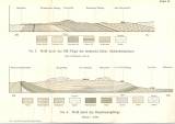
 [Tektonische Skizze der Grafschaft Glatz und ihrer Umgebung] [Tektonische Skizze der Grafschaft Glatz und ihrer Umgebung]No. 3 Profil durch den SW-Flügel des niederschl.-böhm. Steinkohlenbeckerns. No. 4 Profil durch das Heuscheuergebirge ([Tectonic sketch of the Kladsko county and its neighborhood]) (No.3 Cross-section of SW flank of the Lower Silesian-Bohemian bituminous coal basin. No.4 Cross-section of Hešovina [Góry stołowe]) Authors: Flegel, Kurt; Weithofer, K. Anton Country: Czech Republic; Czech Crownlands Document language: German Publisher: publisher not specified, first edition Supplement (Table 2) to a paper by K. Flegel: Heuscheuer und Adersbach-Weckelsdorf. Eine Studie über die obere Kreide im böhmisch-schlesischen Gebirge, published presumably in "Zetschrift der Deutschen geologischen Gesellschaft". Breslau 1904. 3rd part Year: 1904 Scale: 1 : 400 000 Theme of the map: tectonic map Type: Graphic insert Color: Coloured Form: Folded sheet Kind: Printed Original source for this digital copy : Czech Geological Survey, Prague |


