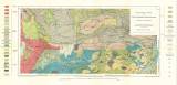
 Geologische Karte der Erzgebirgs-Bruchzone Westlich von Bodenbach Geologische Karte der Erzgebirgs-Bruchzone Westlich von Bodenbach(Geological map of the Krušné hory faul zone west of Podmokly ) Author: Michel, Hermann Author's comment: Lithography A typ. Freytag&Berndt, Wien Country: Czech Republic; Czech Crownlands Document language: German Publisher: Alfred Hölder, Wien, first edition Supplement to a paper by H. Michel: Geologisch-petrographische Untersuchungen im Gebiet der Erzgebirgsbruchzone westlich Bodenbach", published in "Tschermaks mineralogische und petrographische Mitteilungen. Neue Folge, vol. 32. Wien 1913 Year: 1913 Scale: 1 : 25 000 Theme of the map: geological map with Quaternary deposits Type: Map supplement Color: Coloured Form: Bound appendix Kind: Printed Original source for this digital copy : State Technical Library, Prague Original dimensions: 306 x 610 mm (height x width) |


