Wolf, Heinrich
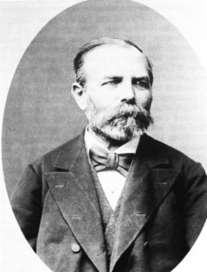 born 21st December 1825, Vienna, died 23rd October 1882, Vienna born 21st December 1825, Vienna, died 23rd October 1882, Vienna
Austrian geologist. Thirst for further knowledge and education led the 26 years old suburban Viennese teacher to join the newly established Imperial Geological Institute. In the beginning of 1850, he was porter during the scientific mission of professor Hauer to the Upper Austrian Alps. Towards the end of the same year he was servant in the above Institute, attended evening classes at the College of Technology and, in 1856, completed the so called 'Nachhilfskursus'. In 1859, he became first probationer, later adjunct geologist, and finally in 1877, the chief geologist at the Imperial Geological Institute in Vienna. He carried out geological investigations in Austro-Hungary, mainly in Moravia. In 1851 - 1859, together with Foetterle, he studied geology of the regions of Jihlava, Znojmo, and Hradiště, and large part of the Brno and Přerov regions. He was mainly interested in applied and engineering geology (water supplies for towns, well drilling, foundation soils, etc.). He established collections of rocks and minerals at the Imperial Geological Institute. He wrote numerous papers and monographs of which the following can be quoted: 'Die barometrischen Höhenbestimmungen der k. k. geol. Reichsanstalt in den Jahren 1858, 1859, 1860' (1863), 'Bericht über die Wasserverhältnisse der Umgebung Teplitz' (1865), 'Bericht über die geologischen Aufnahmen im östlichen Böhmen' (1864, 'Erläuterungen zu den geologischen Karten der Umgebung von Hajdu - Nánás, Tokai und Alja Ujhely' (1863), 'Die Stadt und Umgebung von Olmütz. Eine geologische Skizze zur Erläuterung der Verhältnisse ihrer Wasserquellen' (1863), and 'Über die Gliederung der Kreideformation in Böhmen' (1865).
Works of this author on the medium
- Environs of Rychnov nad Kněžnou, (18..)
 - Environs of Litomyšl and Česká Třebová, (18..)
- Environs of Broumov, (1861)
- Geological cross-section along projected water main line for supply of the city of Teplice with sufficient volume of high-quality potable water, (1865)
 - Geological map of the environs of coal field, intended for water supply for the city of Teplice , (1865)
 - Report on hydrogeological situation in the environs of the city of Teplice with regard to providing sufficient volume of water for Teplice, (1865)
 - [Geological and mine map of the Teplice-Duchcov-Most] map sheet 3, (1880)
- [Geological and mine map of the Teplice-Duchcov-Most] map sheet 4, (1880)
- [Geological and mine map of the Teplice-Duchcov-Most] map sheet 6, (1880)
- [Geological and mine map of the Teplice-Duchcov-Most] map sheet 7, (1880)
- [Geological and mine map of the Teplice-Duchcov-Most] map sheet 8, (1880)
- [Geological and mine map of the Teplice-Duchcov-Most] map sheet 9, (1880)
- [Geological and mine map of the Teplice-Duchcov-Most] map sheet 10, (1880)
- [Geological and mine map of the Teplice-Duchcov-Most] map sheet 11, (1880)
- [Geological and mine map of the Teplice-Duchcov-Most] map sheet 12, (1880)
- [Geological and mine map of the Teplice-Duchcov-Most] map sheet 13, (1880)
- [Geological and mine map of the Teplice-Duchcov-Most] map sheet 14, (1880)
- [Geological and mine map of the Teplice-Duchcov-Most] map sheet 15, (1880)
- [Geological and mine map of the Teplice-Duchcov-Most] map sheet 1, (1880)
- [Geological and mine map of the Teplice-Duchcov-Most] map sheet 16, (1880)
 - [Geological and mine map of the Teplice-Duchcov-Most] map sheet 5, (1880)
- [Geological and mine map of the Teplice-Duchcov-Most] map sheet 2, (1880)
- Explanatory notes to geological and mine map of the Teplice-Duchcov-Most coal basin, (1880)
 |


